

Translation

Wadi Sraya
Area: Umm al-Fahm
Duration: 3.0 hours
Length: 3.0 kilometers
Recommended seasons: All year round
Difficulty: Easy
A short trip along Wadi Sraya, south to Umm al-Fahm.
The trail begins at Al-Mu'alaqa, one of the southern neighborhoods of Umm al-Fahm. To get to the trail head, we turn from road 65 ("Wadi Ara road") to road 6535 toward Mei Ami. We drive for about 2 kilometers, and just before the road turns sharply to the right, we turn right onto a narrow, unsignposted road, which goes down along Wadi Al-Mu'alaqa until we get to the neighborhood, which is located at the intersection of Wadi Al-Mu'alaqa and Wadi Sraya. We turn to the left and drive to the southern edge of the neighborhood, were we may park the car.
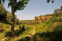
Near the start of the trail there is a large square with a well. To the left of the square there is a steep unpaved road going south-east. We start walking along this road, and after a short distance we leave the road and go to the right of it, into the gorge of Wadi Sraya. From here we go up the gorge, along a narrow, winding trail. The trail used to be marked with blue marks, but the marks are old and difficult to find.
Along the trail we can see vegetable plantations and fruit trees, among them natural vegetation. The trail climbs and lead us up to Sraya springs. Just before we reach the springs there is a small eucalyptus forest, after which we can see a small dam and the springs.
From there we go back along the same way until we reach Al-Mu'alaqa.